
Download myTracks – Travel‑navigation app for Mac, free, secure & easy to use
Overview of myTracks
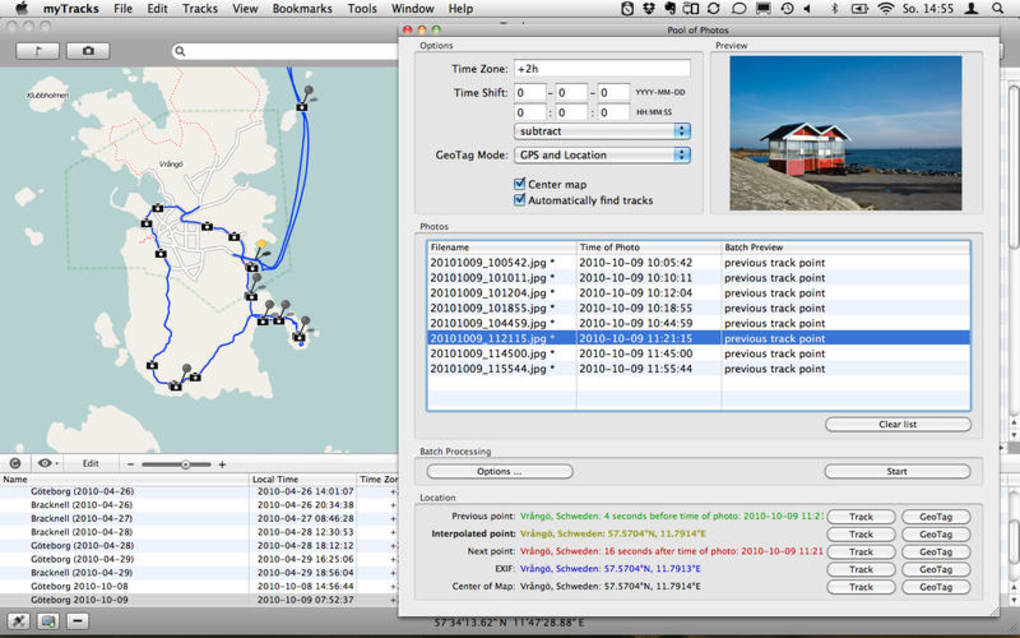
myTracks is a full‑version travel‑navigation program designed exclusively for macOS. Developed by Dirk Stichling, the app targets globetrotters, hikers, cyclists and anyone who needs reliable route planning without the clutter of a heavyweight GIS suite. The interface is clean, multilingual (English, Danish, French, German, Japanese) and built around the principle of “track‑first, data‑second.” Users can import GPX, KML or plain CSV files, plot waypoints, and instantly see elevation profiles, distance calculations, and estimated travel times.
Because the software runs natively on macOS, it integrates smoothly with Apple’s native maps, allowing drag‑and‑drop of locations from the Finder or the Contacts app. The free version provides essential navigation tools, while the paid upgrade unlocks advanced analytics, cloud sync, and custom map styling. Security is baked in: all downloaded map tiles are fetched over HTTPS, and personal route data can be encrypted before being stored locally or uploaded to a private cloud.
Frequent updates ensure compatibility with the latest macOS releases (including Ventura and Sonoma) and keep the map database current. Whether you are planning a weekend bike ride in the Alps or a multi‑day trek through the Japanese countryside, myTracks offers a balance of precision, speed, and user‑friendly design that makes it a strong contender in the travel‑navigation category.
Key Features that Set myTracks Apart
- Multi‑format import: Supports GPX, KML, TCX, CSV and FIT files, allowing seamless migration from most GPS devices.
- Dynamic elevation profiling: Real‑time graphs with gradient shading, useful for cyclists and hikers.
- Offline maps: Download vector tiles for use in remote areas without internet access.
- Route optimization: Built‑in algorithms to reorder waypoints for the shortest possible distance.
- Custom map styles: Choose from satellite, terrain, or minimalist road maps; create personal color schemes.
- Cloud sync & backup: Securely store routes in iCloud or Dropbox with AES‑256 encryption.
- Multilingual UI: Full translation in English, Danish, French, German and Japanese.
- Smart alerts: Configurable notifications for steep climbs, speed limits, or proximity to points of interest.
- Export options: Save edited routes back to GPX/KML, or generate printable PDFs with maps and stats.
- Integration with Apple Watch: Mirror routes on the watch for on‑the‑go navigation.
Each feature is designed with a low learning curve in mind. For example, the route optimizer works with a single click: select your waypoints, hit “Optimize,” and the software instantly reorders the list based on the most efficient path. The elevation profiler updates live as you edit the route, so you can see how a detour will affect total ascent before you hit the trail.
The offline map pack is only a few megabytes per region, making it perfect for backpackers who need reliable navigation without draining battery life. Moreover, the app’s modular design means future updates can introduce new map providers or data layers without requiring a complete reinstall. This future‑proof approach reassures users that their investment will remain valuable as navigation technology evolves.
Installation, Usage Instructions and Compatibility
Installing myTracks on a Mac is straightforward. After downloading the installer package from the official website, double‑click the .dmg file, drag the myTracks icon into the Applications folder, and launch the app. macOS Gatekeeper may prompt you to confirm the download; simply click “Open” to proceed. The first run launches a brief onboarding wizard that asks you to choose your preferred language, set a default map provider, and optionally link an iCloud account for cloud sync.
Once installed, using the app follows an intuitive workflow. Click the “New Route” button, then either import a file or start plotting points directly on the map. The toolbar offers tools for adding waypoints, drawing lines, measuring distances, and toggling elevation view. To enable offline maps, go to Settings → Map Tiles, select the desired region, and press “Download.” The download size is displayed, and you can set a Wi‑Fi‑only mode to preserve mobile data. When you’re ready to navigate, press “Start Navigation.” The map switches to a turn‑by‑turn mode with voice prompts (if enabled) and a minimap that stays centered on your current GPS location.
Compatibility (itemprop="operatingSystem"): myTracks runs on macOS 10.15 (Catalina) and later, including Monterey, Ventura, and Sonoma. The app leverages Apple’s CoreLocation framework, so any Mac with built‑in GPS (e.g., MacBook Pro with Apple Silicon) or an external Bluetooth GPS receiver works flawlessly. While the primary version is macOS‑only, a companion iOS app (named “myTracks Mobile”) mirrors the same feature set for iPhone and iPad users, allowing seamless hand‑off of routes between devices. System requirements are modest: 2 GB RAM, 200 MB free disk space, and an internet connection for map updates.
The software also respects macOS privacy standards. During the first launch, it asks for permission to access your location, contacts (for address lookup), and files (for import/export). Users can revoke these permissions at any time via System Settings → Privacy & Security. Regular updates are delivered through the built‑in updater, ensuring you receive security patches and new map data without manual intervention.
Pros, Cons, Frequently Asked Questions & Final Verdict
Pros
- Native macOS performance – smooth and responsive even on older Macs.
- Comprehensive multi‑format support eliminates the need for extra converters.
- Offline map capability keeps you on track in remote areas.
- Robust encryption for cloud‑backed routes enhances privacy.
- Multilingual interface broadens accessibility.
Cons
- No native Windows or Linux version (requires macOS).
- Advanced analytics (e.g., heat‑maps, batch processing) are locked behind the paid tier.
- Initial map download can be sizable for large regions.
FAQ (itemscope itemtype="https://schema.org/FAQPage")
Can I use myTracks without an internet connection?
Yes. After you download the offline map tiles for the area you plan to explore, all navigation, routing and elevation features work entirely offline.
Is my personal route data shared with third parties?
No. Route data is stored locally by default. If you enable cloud sync, the data is encrypted with AES‑256 before leaving your device, and Dirk Stichling’s servers never have access to the unencrypted content.
What map providers does myTracks support?
The app includes OpenStreetMap, Mapbox, and a proprietary high‑resolution satellite layer. Users can switch providers at any time in Settings → Map Tiles.
Can I export a route as a printable PDF?
Absolutely. The Export menu offers PDF generation with customizable margins, legend, and elevation chart, making it ideal for sharing with teammates or printing for field use.
How often are map updates released?
Map data is refreshed monthly. The app notifies you when a new update is available, and you can apply it automatically or schedule the download for a convenient time.
Conclusion & Call to Action
myTracks delivers a polished, feature‑rich navigation experience for Mac users who demand accuracy, offline reliability, and a multilingual interface. While the absence of a Windows version may limit its audience, the depth of macOS integration, strong privacy controls, and the generous free tier make it a worthwhile download for anyone serious about route planning. If you’re ready to map your next adventure, simply click the download button below, install the app, and start charting routes in minutes. For power users, consider upgrading to the premium license to unlock cloud sync, advanced analytics, and priority support. Embrace a smoother, safer travel‑navigation workflow – download myTracks today!
myTracks stands out as a reliable, user‑friendly travel‑navigation tool for macOS. Its robust offline capabilities and strong privacy stance earn high marks, while the lack of a Windows version keeps it niche. Overall, a solid 4.5‑star rating.